|
Where to fly to
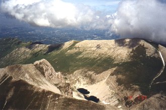
The goal of every pilot that visits Castelluccio is to rise above the majestic face of Monte Vettore and photograph from above it's horseshoe shape that surrounds the mountain lake of Lago di Pilato.
It's not all that simple. Clouds cover must be above 2,500m above sea level, because only then is the mountain's sharp peak uncovered. The winds can't be too strong, as gusts of wind above the sharp peak can crumple the sail of a paraglider into a ball and send a glider wildly sommersaulting above the jagged edge of the mountain. Also as there is no starting point on Monte Vettore, one must undertake a long vault over the valley and then look for another thermal rise on the slopes. It is of course possible with the aid of the Forca di Presta starting point, which lies at the foothills of Monte Vettore, but an easterly wind is not always blowing and not everyone will like a landing below this runway in the event of an unsuccessful take off.

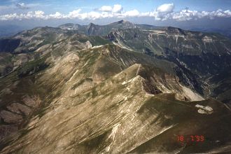
Probably the easiest ticket to Monte Vettore is to start from Forciglieta during westerly streaming and follow with a very short skip to the neighboring western slope of Monte Vettore. When the wind is in this direction and the afternoon sunny it's an elevator to the peak of Monte Vettore.
The mountain lake Lago di Pilato is in reality a curious place. Situated at 1,949m, it is inhabited by a unique type of fish, the Chirocefalus Marchesoivis, which now only exists, maybe, in some parts of China. The winter of 1988-1989 and the following hot summer of 1989 dried the lake to the extreme that these rare fish disappeared from it. But environmentalists fenced the lake off to protect it from wild animals and waited all winter for the following Spring. Following the melting of the snows and re-filling of the lake, the two-centimeter fish came back from somwhere underground and live there to this day.
Lago di Pilato is a favorite vacation spot for tourists and is accessible on foot from the Forca di Presta take off point, by climbing some 700m higher and descending another 300 meters down to the lake.
Our favorite flying route however was a triangle consisting of peaks marked by the monumental cross upon Monte Patino, (1,883m) above Norcia, the peak of Monte Vettore, (2,476m) and the ski lifts at the top of Monte Cappelleta, (1,654m), next to the pass connecting the valley of Castelluccio with the valley of the small city of Norcia. In case of stalling it is possible to land safely in Castelluccio from two of the three sides of the triangle, or in the valley of Norcia from the third.
|

But it is possible to put together a myriad of similarly intoxicated routes in these terrains, whether a pilot completes them or not. An unfortunate aspect is a relatively low operating height, even when the altimeter shows a good 2,500m above sea level.
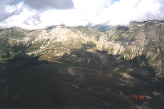
In light of the high altitudes of the local terrain the hieght above the floor of the Castelluccio valley is only 1,200m and photographing the peak of Monte Vettore from this height almost means you have to scrunch up your legs. Height limit is easily attained and pilots used to flying above sea level will surely soon switch their altimeters to compensate for the height of the Castelluccio valley floor.
For non-flying members of the expedition or in case of bad weather it is possible to reach the shore at San Benedetto after 90km of driving and spend the day by the sea.

And maybe even spend all night at the beach ...

|