|
The term "Canary Islands" always brought to my mind rich, fat tourists, lounging around on sunny beaches and drowning their bottomless boredom in mixed drinks with exotic names. A "Last Minute" package from Fischer Travel which included comfortable accommodations and partial meals for 14,000 Czech Crowns for a week-long stay gave me the opportunity to see what it's really like there. The embarrassment of the travel agents at being confronted with strange looking objects, 4 meters long was overcome by an additional fee of 1,000 Czech Crowns, and on the 3d of January 1999 a party of three Moravian hangglider pilots took off for the Canary Islands.
Why the Canary Islands ?
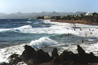
The Canary Islands group is situated 28 degrees from the equator in the Atlantic Ocean, about 110km West of Africa and is spread out over an area of 800 square kilometers. The Azore pressure ceiling together with sea currents and the trade winds are the causes of the curious climactic conditions that predominate on the islands. The average daytime air temperature fluctuates year round between 22 and 30 degrees Celsius, while nighttime temperatures rarely drop below 17 degrees. The ocean temperature fluctuates between 19 and 22 degrees and there are only a handful of rainy days throughout the year. Following a five-hour flight from Prague we landed on one of these islands.
Lanzarote
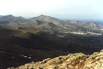
is an island of volcanic origin 60km long and 20km wide. The lack of rainfall and the volcanic origins are apparent with every step. The southeast part of the island is dejecting and unhospitable, as if the last volcanoes had just ceased being active yesterday. There are places where rocks dug from only 30cm under the earth are too hot to hold. In one restaurant a barbecue grill is made out of a grate placed over a deep pit, using the volcanic heat to cook on instead of electricity. It is no wonder then that this terrain was chosen by filmmakers to shoot the movie, "Planet of the Apes".
|
Greenery is rare and only present thanks to aritificial irrigation systems.
From the beaches on the seashore, steep cliffs rise to heights of 600 meters. In the places where there are no cliffs, masses of rock rise to the same heights a few kilometers inland. So it is inconsequential as to what direction the winds are blowing over the island, because you can quickly move to an acceptable runway and hang in the air all day. Slope currents are completely reliable and windless days more or less don't exist.
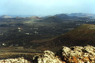
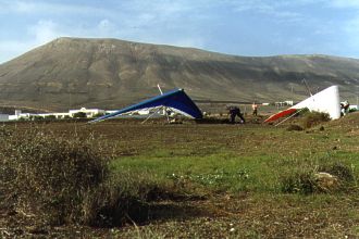
Tinasoria
is a hill with its crest in the southern part of the island at a position of N28°57.217' W013°42.681' about 3km from the shore. Usable wind directions are between 100 degrees to 220 degrees, the best, however, is 160 degrees directly from the ocean. The landing strip by the town Macher lies at co-ordinates N28°56.274' W013°42.216' and over height on the most often used runway is 330m. Almost anyplace along the 1km long crest can be used for take off and it is no problem to land up above on the runway.
|