|
As I later learned, however, its exactitude and the amount of detailed turned out to be closer to a child's drawing than to a good map. Much better was the guide in four languages on the reverse side, even though the trail times seem to have been calculated for marathon runners. At a relaxed pace it will take one and a half to two times longer to do the hikes described in the text.
A cloudy sky greeted us in the morning and outside around the house everything was wet from a night rain. The mood of our expedition fell to zero, but despite that we didn't allow ourselves to be put off. In the interest of simplicity Mila and Hanka together with mountain leader Standa drove out in the morning to the beginning of the trail to the camp of "Refugio el Pilar" and I set out from the cottage. While the below peak group #1 started out at an elevation of 1,400m above sea level, I had to crawl up from 700m. Good thing Standa had refused my plan of meeting halfway and exchanging the car keys. He rather hid them in the bumper and informed of the GPS position of the car. As he correctly predicted, problems didn't take long to arise. Local hiking trails, thanks to frequent fires, ware almost never marked and the only sign pointing towards Fuencaliente (Los Canarios) they found led them to the foothills. All the while they went along a wide forest trail and had they not crawled on all fours up to the last volcano they wouldn't have seen anything.

Even with me things weren't any better. The first part of the trail led through a thick pine forest. At first I tried navigating using the map, but my imagined excellent navigational skills were wholly upset by the GPS. I turned it on to see what time it was and couldn't be more surprised. Fortunately I wasn't too lost. I tried following the map a little further, but after a while struck it in my backpack and continued using the GPS and compass. The forest thinned a lot at the first volcano, the cloud cover I had left far below me and I even ran into a trail marked by little stone men.
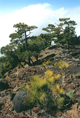
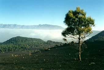
Further on it was simple. The crest is virtually straight and has no side crests. There is nowhere to get lost, and it's enough to follow your nose. The weather was ideal. Sunshine, and not a cloud in the blue sky. Logically so since the cloud cover was based a 600m and ended somewhere around 1,300 to 1,500m. And there was almost no wind in the afternoon. Absolutely super, honky dory.

The southern part of the island, in contrast to the northern side is covered with a fine volcano ash. It's a souvenir of the last two explosions of the nearby volcanoes. Some places it was difficult to walk, like on a sandy beach, and further, on the hills it all kept slipping. A step up, two down, five up, three down,. And as if that wasn't all, the ever-present lizards, not understanding your struggle are always laughing in your face.

We had agreed on first radio contact at 12 o'clock, and of course at that time I was well secluded in a dell and nothing happened. Even an hour later, at the highest point, we were not able to communicate. At least it'll be funny I thought. If I don't find the car, I'll hitchhike back and someone will have to come pick up the car. Good and bad things come in threes and with necessary hum and static we managed to hook up. By that time we were quite far from each other.

It was only a short distance to the car. In a while I descended into the deep forest. He trails criss-crossed, but with the help of the GPS I found the asphalt trail. The display showed only 0.6km remaining. I deliberated a while on which way to go. Finally I headed down a beautiful path directly to the car. I wouldn't take the asphalt road of course.
|
From then on it was classic. "200m to go, I wonder where they parked it. 150 aha there behind that rock, no! Damn!" According to the instrument it is 0.0m to the car, but I'm standing on a trail in the middle of a lava field and wide, except for one tree, there's nothing but black volcano ash. I continued on a way along the trail, but fruitlessly. The car wasn't there and nothing remained but to clamber up the hill back to the asphalt road. After eight hours of hiking it was quite a job. Fortunately, I climbed right up onto the parking lot. At least we had a car with air conditioning, because following that hard climb I was in need of serious cooling. That warning on the GPS isn't there by chance. The deviation was 300m 50m just after the first turn was the path along which I went. It's not bad every once in a while to take your eyes off the display and have a look around yourself.

To The Mountains Again
Enchanted by the beauty of the local mountains I decided to leave out another day of flying and headed out for the second half of the island. This time no one wanted to go, and it didn't surprise me. Ruta de los Volcanes did me in too. Only Standa got up early and drove me to the mountains, taking the opportunity to map out the runway beneath the mountain of Reventon.
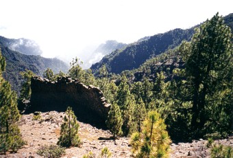
At first it was along a forest path, which after a kilometer or so was replaced by a narrow path, daringly positioned amongst the cliff walls. From the first peak was a majestic view of the southern, volcanic side of the island. I had liked the trail across the volcanoes, but it looked better from a distance. Truth be told, lava and ash, rocks everywhere, it didn't enthuse me much. It was exotic, but here it was through the forest on normal ground, although a bit dry, and the crest above 1,800m had a much more pronounced, high mountain character than the volcano trail. So, a landscape close to my heart.

The trail led across the national park, a circumstance of which I was informed by the signs all around. You wouldn't believe it, but here they don't protect plants, trees and animals, but piles of rocks and lava. It gave me quite a shock when I ran into three rocks fenced by a robust fence, on which a NO ENTRY sign was fastened. Evidently they were of a different material. Who knows, maybe elves brought them here. On our next trip I'll have to ask Winston, or maybe we'll take along a flying geologist.

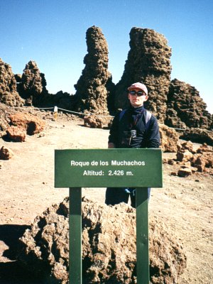
Navigation was simple because there were signs at all the major intersections, here and there a mark on a rock and the forest section was short. Only occasionally on the crest did I lose the trail in the thick underbrush. A couple of times I had to climb a cliff and find the way. The weather turned out for me again, the clouds were far below me. A strong wind was blowing, but mostly I walked in shelter. The idyllic mountain setting was broken up 3km before Roque de los Muchachos by an asphalt trail, which stayed with me the remainder of the way. In the mountains the Canarians have fenced off rocks and here at the peak they go ahead and put in an asphalt road from two different sides. The most maddening was the section I was forced to walk humbly along an asphalt road.
I reached the highest peak at 4:30 I the afternoon, that is 8 hours of very fast walking. If Standa hadn't driven me to the base of the mountains in the morning, I don't know where I would have gotten. Further I had originally wanted to start out from the camp of "Refugio el Pilar", from which we had driven 6km along a forest road.
And thanks to the nice weather, a lot of tourists had come up. I didn't even try hitchiking, we had driven here quite a while and spending the night among the cactuses didn't appeal to me. So I just got right into a car with some French couple and in two hours and a few minutes, hitching a couple of other rides that I didn't even have to wait long for, arrived at our house in Fuencaliente (Los Canarios).
|