|
And the sun beats down ...
As can been seen immediately from any good map the terrains in Castelluccio lie between 42nd. and 43d degree North, which indicates that the noon height of the sun above the horizon in the summer months will be damned high. And so it is. Even though it was already a month after the solstice, almost nothing had a shadow and to find out where the sun was, one had to crane his neck way back. This has an interesting effect on local convection. The unusually high position of the sun eliminates differences in southern and northern slopes in terms of their sunniness. Much bigger differences in temperature can be expected between western and eastern slopes, obviously opposite in the mornings and afternoons.
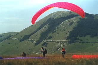
Castelluccio is a terrain full of extremes not only in temperatures and other previously mentioned realities. The fact that an experienced pilot as well as a complete beginner will have great flying also deserves mention. True, this may bring to mind the commercial, "Wet but dry", but that's the way it is. Lubin would have a few exceptions, like there are a lot of rocks lying about in the hills, but if I were to teach a flying course somewhere outside of the Czech Republic I would certainly choose Castelluccio. The southeast side of the valley is made up of steep grass-covered hills similar to our Rana hill, on which you can take off very easy. It's possible to fly from them on all sides and as we saw from up high flying courses are really taught there. Otherwise you can climb up a slope anywhere and after take-off land again anywhere on the vast flat area of the valley, which is named Piano Grande, that is, big plain.
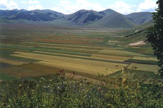
Very curious are the little forests of low trees that occur occasionally on some of the slopes and are of course artificially planted. Planted in a strange way, however. The forests form, from the air, patterns of individual continents, as if on a map. So looking out over the valley, a pilot can see to Africa, North and South America, Asia, Australia and of course Italian nationalists included a forest in the shape of the Italian boot.
The entire valley is a national park protected by UNESCO, so that one find toilets with paper included and waste containers. On the North side of the valley is a gathering of stone houses bunched close together and forming the mountain village of Castelluccio.
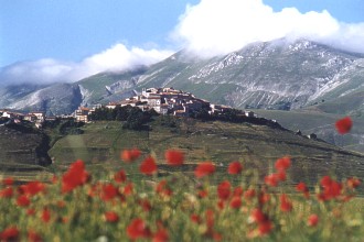
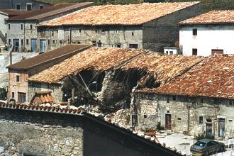
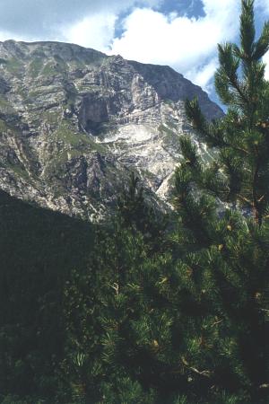
Castelluccio is situated in a seismic area that two years ago suffered an earthquake, the signs of which are still visible today.
Other than the occasional earthquake, though, the village is beautifully peaceful and easy going. Local merchants sit in front of their shops, not hurrying anywhere, and are happy to chat with a foreigner. After suggestive praising of the 3-year old, dried and salted meat called Prosciutto, we couldn't hold out and bought some leg to try. It is said to be best enjoyed with red wine, and immediately following a taste, our entire expedition divided up into two camps. One side thought the three-year old raw meat a little odd, while the others declared it unpalatable without red wine.
It is considered a courtesy to visit the local flying school in Castelluccio where on the first day of his stay every pilot writes his initials, address and pilot licence number in the registration book. The school is easy to find by following the arrows with signs saying, "ProDelta", or by asking any of the local residents who will gladly show the way.
|
The village is unbelieveably small and impossible to get lost in.
Visiting the school is a good idea for two other reasons. For one there is a shop that sell flying supplies, everything from helmets to walkie talkies and further, every pilot, upon signing in, receives a free, simple map of all runways, including a list of important telephone numbers, frequencies and regulations. Throughout the day in the ProDelta center the frequency 146.800MHz is available for questions on weather or to call for assitance in case of unexpected difficulties or events. Every morning it is also possible to look at printed satellite pictures of weather over Europe and during the day for 60 Czech Crowns a pilot can even take a shower. Unfortunately you cannot expect the Italians to function before 9 in the morning. At the little hotel, "Sibilla", in the village it is possible to buy for just under 200 Czech Crowns an excellent map of the area, in a scale of 1:50000, segments of which we used in the Flying lanscapes section to show local runways.
Where best to take off from
Without exaggeration, it is possible to say that taking off is possible from any place the pilot sees through sleepy eyes when he steps out of his tent in the morning. Understandably this depends on wind direction or in case of lack of wind, by orientation of the slopes in relation to the position of the sun. A detailed description of the most frequently used runways can be found in the Flying lanscapes section. Namely during southwest or westernly streaming we witnessed the climbing on foot of some paragliders to roughly a quarter of the hieght of Monte Vettore and following their take-off, they climbed to the peak without problem. They were only forced to land in the basin of the valley by the encroaching darkness of the late evening.
All of the runways in the vicinity of Castelluccio are perfect, almost schoolish. No turbulent wind sections, no tree stumps. A big slope, mountain grass everywhere, here and there some rocks, we are in the mountains, after all, and of course the occasional dry sheep turd. But best of all is the comfortable feeling that immediately under the runway it's possible to land anytime on a wide flat surface.
The only exception is possibly the Forca di Presta runway where it is necessary to land on the spacious, but rippled meadows in the valley of Castelluccio. But one doesn't often land on these meadows from these runways, rather rises uncompromisingly along the eastern slope of Monte Vettore above its peak.
Thermal currents at these altitudes above sea level start working before the noon and some days towards evening the valley is so warmed up that you can fly above it with your finger in your nose until dark. According to local paragliders, with good visibility it is possible to see the ocean on both sides of Italy upon attaining sufficient altitude. From our own experience we can only confirm the visibility of the ocean on one side, East of Italy, from a height of 2700m above sea level.
According to local pilots talking 1998 was extremely hot and dry. The grass turned brown and dust devils were seen to pull up tents and whirl them 20m into the air from the floor of the valley. No one said whether or not there were people in the tents ...
|