|
World Map
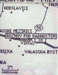
GPS 12 MAP contains, in addition to user-input coordinates, millions of pre-programmed points, making up a map of the world. Highways, railways, roads, cities, rivers, lakes and ponds. Of course we were interested in the changes between this map and the map in the GPS III Pilot, whose "Valadska Mazidiada," meaning "Valasske Mezirici" amused us considerably. The hometown of the band "Mnaga and Zdorp" is correct this time, though the road connecting " Frydlant n.O. and Frenstat p.R.", was again not found. However, the system did correctly show all the little villages that are scattered along that road - Celadna, Kuncice pod Ondrejnikem, Ticha, Kozlovice and so on. It is even possible to find the villages of Teplicka near Zilina under the well known by all pilots hill Stranik.
It is possible to mark off a course on the map using the cursor and calculate the distance between any two points or by pushing one button to change any point on the map to a user-set point, or Waypoint. In this way setting a route across unknown territory without overestimating is a laugh.
Sometime this year CD's with very detailed maps of all the countries of western Europe are to be made available, and it should be possible to transfer this information, via computer connection into the GPS. Unfortunately the Czech Republic and other eastern countries will be available later on.
Map Scale and Buildings
The map scale can be set from 800km to 30meters, while map scale can be assigned to objects on the map such as cities, roads, railways, lakes, to display them in scale. It is possible to define that up to a scale of 100km only cities will be visible, less than 100km roads, below 50km, water surfaces. Display of various objects can be completely turned off. To make things more precise, cities are divided by size into four categories. Each of these categories can be seen as an object and assigned the above-mentioned values.
|
User-set Points
The maximum amount of user-set points is 500, with the title of each point having up to six letters, while their descriptions up to 20 letters or symbols. Each point can also be shown on the map using a graphic symbol, which can be not only descriptive, such as a phone booth, tower, golf course, restaurant etc…,but can lump points into groups. The connecting characteristic of points then becomes this symbol, of which there are 74.
Averaging Measured Positions
This is an excellent function, which enables unusual precision of measured co-ordinates by statistical elimination of deviations inflicted by the Selective Availability Program of the Ministry of Defense of the United States. Of course even here it's something for something. The averaging of position is quite time demanding. The instrument keeps track of how long it has been averaging and numerically increasing the precision of measurement. If your patience gives out before the batteries, with a push of a button you can write the exact position and continue with optimism towards the next point.
Routes
It is possible to assemble routes from user-input points. The instrument is able to save in memory a maximum of 20 routes, while each route can contain up to 30 points. Following activation of a rout the instrument infallibly navigates from the first to last point on the route.
Track log
The notorious "Track Log" can contain up to 1900 automatically recorded positions, or points, and ten of these logs of trips can be saved in memory. The memory-recorded logs, however, contain only 250 of the most meaningful point of the trip.
Trip Computer
With the help of the "Trip Computer" it is possible to precisely monitor interesting data of the current trip or flight - measured time, distance average speed, maximum speed. All values can be zeroed at any time.
To Buy or Not To Buy ?
There is no universal answer to this question. It always depends on the demands of the user and his financial means. This instrument certainly doesn't belong among the cheapest but on the other hand, you'll have to search long and hard to find faults with this instrument and even then it's not guaranteed you will. The above description is not a total summation of all of the instrument's capabilities, as there are several times as many as are mentioned here. For example only in the Track Log function there are seven variations of marking individual route points, and we could go on through all the functions.
The Garmin GPS 12 MAP is without contest the best instrument that we have tested so far. The Garmin GPS III Plus, whose test we're preparing for the beginning of next year, will be slightly better, but only in small details.
|